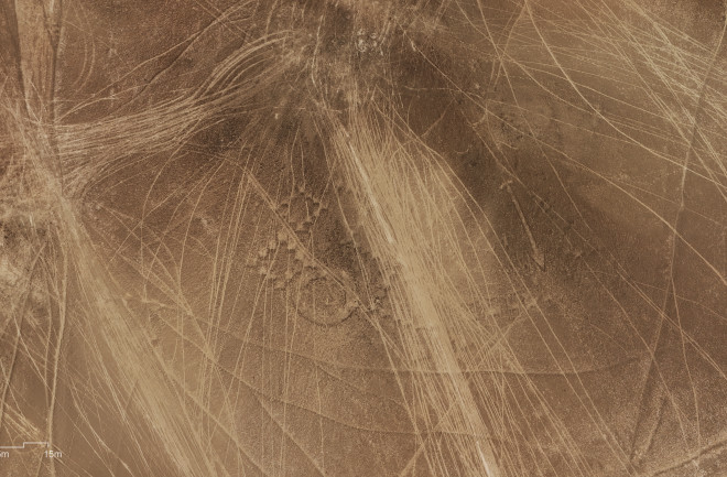
 Vehicle tracks showing destruction of the geoglyphs by off-road racing, courtesy Atacama Desert Foundation.
 CHILE – Off-Road Racing is Destroying Chile’s Ancient Geoglyphs
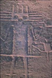
The Atacama Giant: Geoglyph of Cerro Unita, Pozo Almonte, Chile. Luis Briones (c) 2006
The Atacama Desert Foundation has documented significant damage to the Alto Barranco geoglyphs in Chile’s Atacama Desert caused by motor vehicles, including motorcycles and 4x4s. Unlike the massive Nazca Lines in Peru, which are recognized by UNESCO as a World Heritage Site, only a loosely enforced National Monuments Law protects the Chilean geoglyphs.
In the past, they were used as targets for Chilean Air Force bombing pracice – and between 2009 and 2015, the Dakar Rally (moved at this time from Africa to Chile and Peru) annually sent hundreds of vehicles, motorcycles and trucks through the fragile landscape, damaging at least 318 archaeological sites in the Atacama Desert. The geoglyphs, some over 1,000 years old, continue to be destroyed by off-road riding, a popular activity in the region.
The foundation used photogrammetry and drone footage to capture images of the tire tracks crossing the region and cutting through the figures.
Archaeologist Gonzálo Pimentel expressed alarm at the severity of the damage, which he described as the worst destruction ever done to the ancient figures. He warned that the lack of protective measures could make restoration nearly impossible and predicted more incidents in the future. The Atacama Rally, a local off-road competition, denied any involvement in the damage.
The geoglyphs, similar to Peru’s Nazca Lines, are mostly visible from high altitudes and were likely created by removing soil to expose lighter sand. They are part of a network of routes used by ancient llama caravans over 3,000 years ago.
PERU – AI Reveals Hundreds of New Geoglyphs
In 2022 and 2023, archaeologists from Japan’s Yamagata University working in Peru and researchers at IBM’s Thomas J. Watson Research Center used AI to study 629 square kilometers of Peru’s Nazca Desert. They found over 47,000 potential geoglyph sites, refined and narrowed the data to 1,309 promising candidates, and then used fieldwork and drone survey to verify 303 previously undiscovered geoglyphs in just six months of field study. Of the new geoglyphs discovered, more than half were suggested by the AI model and the rest were located during follow-up fieldwork.
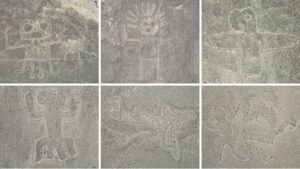
Nazca relief images with outlining to demonstrate their outlines. courtesy Yamagata University Institute of Nasca.
The researchers were seeking smaller sized relief geoglyphs in the desert 50 kilometers inland from Peru’s south coast, which are far harder to spot than the well-known giant Nazca Lines. In the published paper, the smaller relief-type figurative geoglyphs are said to average only 9 m in size. They most often depict humanoids (sometimes human sacrifices illustrating decapitated heads) and domesticated animals, especially llamas.
The study mapped networks of trails from which the geoglyphs would be visible to a walker, suggesting that these glyphs, more easily seem by humans on the ground, might form part of a religious activities or a pilgrimage route and also be associated with practical applications such as identifying water sources and facilitating trade.
The finds by the Japanese-Peruvian team almost double the number of known Nazca geoglyphs, which date as far back as the Initial Nasca period (100 BCE to 50 CE) and continued to be made until the 15th century CE. Another 968 sites remain to be surveyed, making it probable that hundreds more geoglyphs await discovery.